|
Popis |
In the bedrock of today's rock massif lies, as in the wide
surroundings, a crystalline layer of shale. Crystalline is formed by deep
igneous rocks (biotite gramodiorite) of Paleozoic age, which were partially
transformed (metamorphosed) to slate during other epochs.They rise to the
surface only near the mouth of the Suchá Kamenice stream (they were mined in
the quarry - today the parking place situates south of Hřensko). Other
transformed layers can be traced to the form of crystalline limestones (Maxičky
and Sněžník).
Further development took place north of the town Děčín (the Lusatian granite mass - probably the
pre-Kambric age, the Permian layers, the Jurassic sediments of conglomerates,
limestones, dolomites and marlstones), but it is for our purposes and therefore
we will not deal with it. In the present-day Děčín basin, the denudation
process (aligning the terrain to parovine) seemed to take place at that time,
and other changes were noticed in the Upper Cretaceous sedimentation of the
surrounding massifs in the Cenomanian - Turon levels, in the upper parts by
Coniac - Santon. Subsequently, the dry land period lasted tens of millions of
years, when the Děčín basin was part of a vast mainland extending from central
France to the western edge of the Russian Board. In the Oligocene period (older
thirds), sandstone layers were strengthened by chemical processes (silicic acid
action) and later by mountain-forming processes (volcanisms and tectonics of
the Alpine-Carpathian fold). During this period, a world-famous diatomite
sedimentation basin was created, later known as the Bechlejovice Wall. There
was a tertiary occurrence of crustaceans, insects and amphibians, as well as a
number of woody plants and other plant species (about 75 species). Similar
diatomite sites were also found in Huntířov, Brložec and Soutěská, near
Markvartice and Veselíčka.
During the Lower Miocene (Upper Third Territory), the first
non-volcanic phase took place in our territory from northwest to southeast.
Volcanism manifested itself in the west, south and east of Děčín by surface
forms - lava sheets and streams that penetrated through sandstone layers. On
the other hand, the forms of subsurface volcanism - often in the form of
fillings of volcanic fluxes, veins and inlet channels to surface spills, as
well as their own subsurface bodies that originally did not reach the surface
of the terrain at that time - they are
often found on the edges of the České středohoří and valleys of deeply cut
watercourses. It is composed of phonolites, trachytes and basalt. The most
beautiful example of the prepared flue is the Vrabinec Hill (351 m above sea
level) near Babětín, further distant from the Panská Rock near Kamenický Šenov,
or the Zlatý vrch above the Líská Basalt
Organ). Remarkable is the horizontal columnar separation of the jingle on the
Pustý zámek near Česká Kamenice. Originally there used to be a quarry whose
mined columns form the lining of the Long Ride.
While the
western, northern and northeastern parts of Děčín and its surroundings form
hardened sandstone of the Upper Cretaceous, in the east, south and southwest
the landscape is formed by the above-mentioned igneous rocks (jingles, basalt,
trachyte). The present appearance of the local landscape was modeled by the
Elbe with its tributaries - Ploučnice, Jílovský potok and several smaller
streams. From the morphological point of view, the most important landmarks are
Pastýřská stěna, Červený vrch, Kvádrberk and Zámecká skála, on which the
Tertiary Sokolí, Pustý vrch, Chlum and Vrabinec follow, the Sedmihoří,
Chmelník, Lotharův vrch, Popovický vrch and Klobouk on the left bank of the
Elbe. to Popovický vrch and Vrabinec about 500m); the highest mountain of the
Elbe Sandstone Mountains - Děčínský Sněžník (723m) looms over the horizon above
the Jílovský creek valley. On the edges of some sandstone hills there are signs
of small rock towns (Kvádrberk, Pastýřská stěna, Sněžník).
The oldest evidence of the Děčín Basin originated from the
younger Pleistocene (the Wurm Grade) is the river terrace on Focke Heights at
the former confluence of the Labe and Ploučnice Rivers (today's hospital
complex at an altitude of about 200m). Interesting is the occurrence of
material of northern origin (especially flint *). This gives us an idea of
the altitude of the Elbe. At that time, the landscape seemed to have a rather
flat impression from which today's Růžovský and Arnoltický vrchs stood out in
the north.
* It does not mean, however, that the northern iceberg's
forehead is here! He created a moraine in the area of Jítravský sedlo, and
its deposits were transported here by Ploučnice and its tributary, the Panenský
brook.
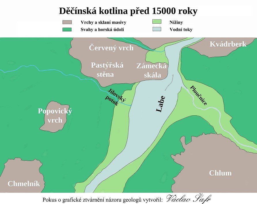
After the massive melting of the glaciers and the numerous
floods, the river valleys deepened and widened. Despite this, according to the
opinion of geologists, the Shepherd's Wall with the chateau rock formed almost
one massif until the end of the last ice age, and the Elbe flowed along the
eastern side. This is evidenced by the multi-meter alluvium in the original
riverbed. / gpfg p. 105 The eastern side of the Shepherd's Wall was uncovered
during this, certainly dramatic event. The original Elbe flow was followed by
Ploučnice, which flowed into the Elbe somewhere in today's Shooting Range.
Indeed, this is evidenced by the fact that in the Middle Ages, the Ploučnice
arm, which supplied several ponds, brought water here (one of them was in the
area of today's Cocos, another in the pit behind the Business Academy, and
the third - called Dean's). lay west of October 28th). Ploučnice's shoulder
gradually became clogged, and the ponds turned into swamps. After drying, the
area of former ponds was used to grow vegetables, and other crops. The
original shape of the ponds is still visible in the field, and later on the
last two sites, a horticulture ** was built, which remained until the mid-20th
century.
** there were many in Děčín, later built-up area before
Shooting Range was originally called Zwiebel-garten, literally onion garden,
rather it meant vegetable garden.
According to the old plans of the city, Ploučnice flowed
into the Elbe until the 1870s on the site of the northwest railroad bridge. At
the time of the bridge's construction, the Ploučnice River was extended and the
Elbe River in its present position. Of course, the Elbe was not regulated until
the mid-19th century, so the banks slowly sloped down to the water surface.
Also the trough of the Jílovský potok has changed its appearance and position
of its entrance to the Elbe several times in the last 150 years. Originally the
Jílovský potok was under the Pastýřská stěna, at the time of the construction
of the railway the outlet of the stream was moved about 150m below the railway
bridge over the Elbe - approximately against the viaduct of the mototechna; In
the mid-1990s, the stream flow was shortened again, and its estuary was moved
to its present location - about 150 m in front of the railway bridge.
There were two large quarries in the Pastýřské stěny area:
the first one on the south side of the hill, in front of the current southern
tunnel portal - it provided quality sandstone. The stone of poor quality and
sand was mined on the SE side, behind today's restaurant. The poor quality and
stability of the rocks of this locality was probably the cause of their rushing
in the winter of 2017-18. / bnlk
Although the eastern part of the Pastýřská stěna is
considerably more stable and of higher quality than the southern side, rock
blocks were raging here. Road and rail transport have had a major impact on
these phenomena, and surprisingly, as shown by the measurements below, ship
shipping in particular. Therefore, in the mid-1960s, a mountaineering group was
established as part of the City's Technical Services, which took care of the
safety of the rocks. At the same time, rocks were monitored by Geology Prague,
which in the 1970s developed a project to stabilize rocks with special belay
anchors. The project was implemented in the second half of the 1980s, but after
1990 it was canceled without completion.
/ gpfg - Glöckner Petr: The Physical-Geographic and
Geological Conditions of the Děčín District Nadace Vlastivěda okresu Děčínského
- Series Nature 1995
/ bnlk Belisová Natalie: Quarries in the Elbe Canyon in:
Kámen, revue kamen.cz
|