Hiking on the Shepherd's Wall
| Popis |
Introduction: There are a number of theories about the name of the massif. The original German name was "Schiefe Wand", or "Sloping Wall". It matched an observable bow of the view from the east. This name evolved into the meaningless "Schiefenwand", ie "Slate Wall". And since there was no slate there, the name "Schäferwand", the "Shepherd's Wall", was used. The latter is covered by the legend of a pimp. Either way, postcards with the silhouette of "Sleeping Shepherd" began to be published.
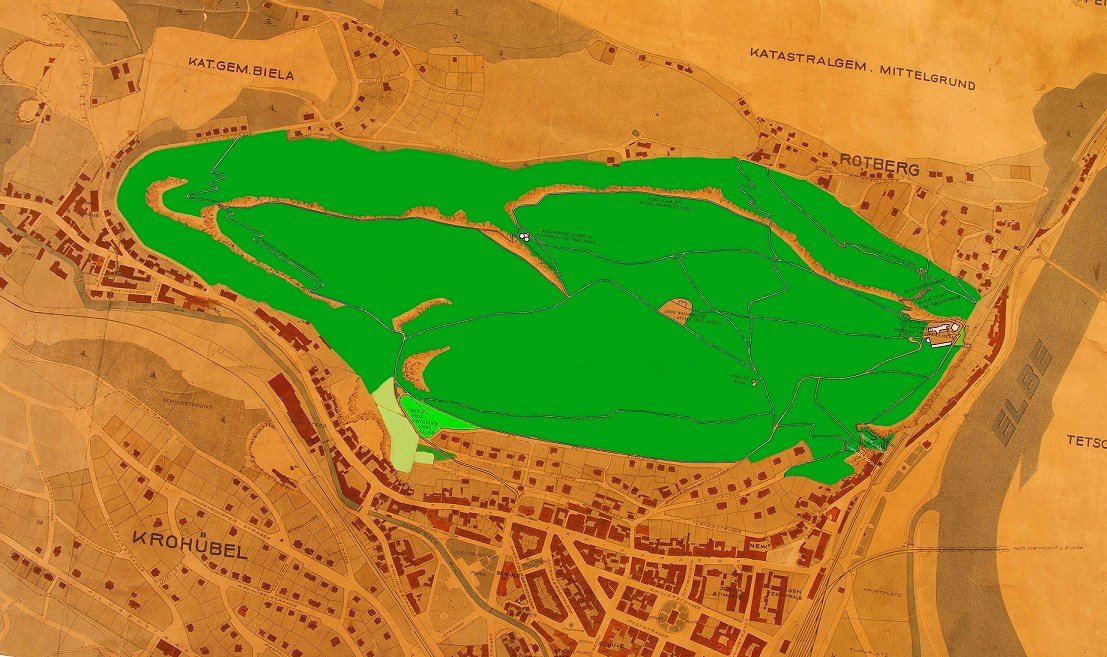
I. From the beginning to the end II. World War II: The first mention of the accessibility of Pastýřská stěna relates to the operation of St. Joseph's Spa in Horní Žleb. In 1822 Count Thun had the tops of hills on the left bank of the Elbe (Pappert, Vrásník, Červený vrch and Pastýřská stěna) accessible to the spa guests through a network of roads. Soon he had them supplemented with prospects, benches and things like this. The main climb to the summit probably led from the saddle of today's district Červený vrch. With the construction of the railway and the subsequent development of the town of Podmokly, there was an interest in using leisure time especially on Saturdays and especially on Sundays. Like the other peaks around the town, Pastýřská stěna was gradually and, in particular, at the end of the 19th century, accessible through a network of paths. In 1892 a log cabin was built by the Mountain Association for Czech Switzerland near today's restaurant. After becoming a town in 1901, it was soon decided to build a representative building of a brick restaurant in the form of a romantic castle with a lookout tower and guest rooms (today it is a citizen of Děčín Nebíčko or Zámeček). Completed in 1905, the complex included a large wooden terrace that was used as a dance floor in summer and as an ice rink in winter. The edges of the top plateau were complemented by views of the city and the surrounding area, and connected by a network of paths paved with sandstone stones, benches and several gazebos. A narrow access road was built to the top of today's Teplická Street. The maintenance of the access roads and the building of the others was done by the Podmokel Beautification Association. From the railway crossing from today's Puchmayerova Street, the ascent to the restaurant was made possible partly in the rocks, as evidenced by the inscription at the top of the road: Felsensteig - Rotberg - 1899 * (which could be translated as a rocky trail to Červený vrch); A similar trail leads from Bělá to the westernmost point of the hill, Bělské vyhlídky. The Felsensteig crosses the so-called Grabensteig (Dirt Trail), running alongside it from the restaurant to the Nord-Kammweg (Northern Ridge Road). On the way up from the Evangelical Church along Fritsch Wiese (Fritsch Meadows, the so-called Palouka leads to the Bělská Viewpoint Westlicheweg 1904 - The Western Route. From the railway tunnel near the viaduct in 1906, a road was partly cut in a rocky gorge called the Teufelsschlucht (Devil's or Devil's Gorge). The memorial was apparently removed soon after the end of the war, the fact that only the base of the pedestal was preserved from the memorial, and the gradual ascent allows access from Reslova Street, the Evangelical Church, the Red Hill and the Scrapers. According to the publication pnht (p. 8-9) organized tourism in Děčín (Gebirgsverein für die Böhmische Sweiz / Mountain Association for Czech Switzerland) was established in 1878, ten years earlier than in other regions of the Ústí Region. At the end of this year it had 120 members. And soon it spread to many villages of the current district, including Podmokely. In addition to marking the paths cut in the rocks, there were parallel markings shaped on trees or columns, in the border region taken from neighboring German countries. However, as pnht claims, German mountain associations have been markedly confusing, the worst in northern Bohemia (p. 117). The reports have not been preserved about the specific form of the signage at Pastýřská stěna, but it can be assumed that they were usual in the region. Brands had rectangular in shape, diagonally divided into two triangles, the top of which was white, and the bottom colored (red, blue, yellow, green and black). In addition, a special comb-shaped mark has been agreed for the ridge hiking trails: a blue "four-tooth" crest lay on a white field. The ridge road led from Sněžka across the Krkonoše, Jizerské and Lužické mountains, the Ore Mountains to Smrčiny near Aš. Due to the North Kammveg map, the use of this mark on the Shepherd's Wall can be expected. So far, the worst part was their use. The variety of brands and the ambiguity of their use on the intended route were criticized. * - the names of paths and other preserved objects are listed in the text and on the map in the original, ie German version. This is because some of them can be found carved on the rocks, as a memorial to the first tourist signs in the area. Try to create a children's game on this topic. In 1919-25, the Waldtheater - Forest Theater, was built above the top of the access road climb, where the Pilz Theater in Podmokel played its performances (this company had a permanent scene in the Podmokly in a building opened in 1901 under the name "Zur Stadt Dresden"). The forest theater was characterized by its cramped dimensions, and two smaller houses, part of the gamekeeper's lodge, were also part of the scene. The auditorium was fitted with wooden benches. / hrds On the site of the Forest Theater in 1936, the Mountain Association for the Czech Switzerland built a youth hostel. On the map of Podmokel from 1938, the so-called Schiller Baum is drawn near the crossroads under the Forest Theater, planted in the year of the 100th anniversary of the death of the poet, probably oak (?). In the same year, Schiller's oak was planted in a park in Kvádrberk, but it survived. ** - Forest or even rock theaters had a great tradition in the borderland. They were probably modeled on a rock theater built at the turn of the 18th and 19th centuries by Clam-Aldringen at the Belvedere at the Elbe Hills. For example, theaters in nature originated in Karlova Valley at Šluknov, Mlýny (1931), at Sloup v Čechách, the Rock Theater *** in Kurort-Rathen, Germany is also known. The fact that old rock theaters are being restored, for example in the former stone quarry near Nýrsko, or the creation of a new forest theater near Srbská Kamenice, is a pleasant phenomenon. *** - we can visit the so-called rock theaters, ie interesting rock scenery: one of them lies southeast of Hamr on Jezeře (a small rock gate), another below Popová rock in the Lusatian Mountains or in the more distant Broumov Rocks. Certain parts of the forest park were undoubtedly modified by the park, besides the surroundings of the restaurant and the Forest Theater it was, for example, the Fritsche Wiese horseshoe-shaped shape, now called Palouk the Černá Kladno restaurant. From the evangelical church, the beautiful, stone-paved path leads to it, originally with a loose sand surface and benches. Smaller landscaping could originally have been around the monument of F.L.John of 1908.
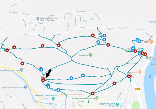
II. Hiking on Pastýřská stěna after II. world war: Unlike Kvádrberk, the restaurant was reopened after the war, following up on its pre-war fame. Higher attendance of the local restaurant probably contributed to the location in the middle between two city centers, while Kvádrberk still lay somewhat outside. Unfortunately in recent years its operation is limited to the summer season, for the rest of the year on weekends. At the entrance there is a possibility to visit the tower tower in agreement with the staff. The popularity of the Pastoral Wall was also strengthened by the early establishment of the Zoological Garden at that time, the fourth in Czechoslovakia. It was placed in the area around the former Youth Hostel, which since 1948 served as the seat of the administration of the zoo and several thermophilous species of animals. Today it has an area of 6 hectares, has 450 animals, birds and reptiles in 150 species. The predecessor of the zoo was a zookoutek with cages for animals behind the restaurant building, founded probably just after the war (about the time of its creation and my failure to find credible information. The truth is that according to witnesses still in the 70s were kept in cages birds. After 1980, a vertical tunnel was struck by the eastern massif of the wall with the intention of creating a facility similar to Germany, a popular lift for the Königstein Fortress. Although the lift was put into operation in 1983, it was only in service until 1994. The proclamation of the usability of the lift and the availability of the Shepherd's Wall for the Disabled was soon taken up by the elevator, and it did not take into account the possibility of importing disabled people to the restaurant by car. The end of its operation was due to the unprofitable operation, and mainly to the non-concept of the project: a long corridor with a set of staircases, both at the bottom and at the upper lift station, led to its own elevator. The original tourist route marking in the spirit of German customs was changed after the war according to the rules of KČT. According to the publication pnht (pp. 35 and 118) in 1946, Josef Pařízek, the designer, marked the first Czech trail from Podmokely across the Děčínský Sněžník to the Tisské Walls. If she led the route today, she had to cross the Shepherd's Wall. By the way, since the spring of 1947, the marking of the whole of Bohemian Switzerland began, and in 1948 orientation signs were posted. On the other hand, they were worse off because in the confusion after 1948, when the Communists tried to centralize all activities, it was not the time to rationalize. New guidelines for the marking of hiking trails were published in 1955. For many decades, a red tourist trail *, which has been part of the international long-distance E 3 route with a total length of 6950km, passes along the ridge of Pastýřská stěna. It leads from Santiago de Compostela, Spain to Bulgaria. * tourist signs in the Czech lands have not changed since the beginning (1888). It always had a band shape, only the middle, colored strip was initially stronger (it should be added that in the border areas, the hiking trails managed by German mountain associations were marked differently). Initially the white-red markings were gradually supplemented with blue, yellow and green middle stripe, turns to castles, ruins, caves, lookout points and hilltops were shaped in shape. Direction tables at the crossroads were tasteful - they were made of larch wood with dark blue descriptions. pnht (p. 116). After 1920, Slovakia also took over our branding (black and brown were used in addition to the above colors) and Carpathian Ukraine (since 2007 it was renewed with financial support from the Czech Republic and Poland), and after some World War II, the GDR and Poland differed. As published in pnht (p.121), the old but modified ridge path markings (Kammveg) return to the German routes in the Ore Mountains: on the white rectangle with a blue center stripe, the upper white stripe is Kamm. According to experts, our tourist markings are the best in the world for their simplicity and clarity. Who moved in the field west of our borders will give this view 100% right! A few years ago, there were 4 Nordic Walk routes for dynamic walkers in the forest park area, totaling 17km. For my person, I do not understand why this should be a common sport activity of a limited group of people in the field, where it is impossible to get lost. Either someone did not know what to do with money, or the mental abilities of pedestrians were underestimated. Not to mention the weediness of the park with signs and signs! One of the biggest attractions of the area since 2014 is Ferrata with the entrance to the former lower lift station. He has built Ferrata with the support of the sponsor and town Karel Bělina, who has been managing it with the help of friends to this day. At present, there are 15 secured roads with ladders, footrests and steel ropes and varying degrees of difficulty. The entrance to the Ferrata is free of charge with the use of belaying equipment (possibility to borrow in the rental office for a fee). Less experienced tourists can arrange guided tours. The elevation is 95m, depending on the route selection 150-170m, difficulty level B-D. The wall is accessible seasonally in accordance with the rules for climbing in sandstone rocks, ie from the beginning of April to the end of October (with slight overlap in good weather). It is not possible to enter the wall in the rain and on the wet surface of the rocks. Ferrata has quickly gained the interest of those interested, and several tens of thousands of climbers from all over the Czech Republic and abroad visit it every year. In recent years, several artistically rendered benches in the form of sculptures by Dmitry Pljonkin have been installed in the Pastoral Wall area.
pnht - Karel Punčochář, Václav Novotný: History of organized tourism in the Ústí Region hrds - Havránková Regina: Theater in the Sudetenland (Děčín Region in 1900-1938) (p. 26) DP Charles University Prague 2017 (inter alia, used references to Hana Slavíčková's publication: Decin stop). |